Thursday 16 August 2012

www.freeskiing.dk

Freeskiing.dk is a Danish blog about freeskiing and skiing in general. They hope to raise or increase their readers interest for skiing. They love skiing and to write about skiing and they hope to make even more Danes aware of the joys of skiing. Freeskiing.dk tries to cover as many aspects of skiing as possible, whether it's how to do your cork 7, how to ski deep powder or how to initiate a carving turn for beginner. It's all about skiing and the people, at Freeskiing.dk, just love skiing.

And that's why we got a chance to post an article about skiing in Banff:

http://freeskiing.dk/job-ski-canada/ 

Tuesday 14 August 2012

Mt. Rundle


Notes to myself: (Before starting to hike a 9-10 hour advanced hike/climb)
  • Cut your toenails, walking down a mountain for 3-4 hours putting pressure on your toes, it’s not pleasant, you might loose a couple! (I got 2 blue nails)
  • Blister bandage, hiking/climbing up hill for 5-6 hours are putting a lot of pressure on your heels, result if your are not prepared, an inch diameter big blisters on each heel.
  • Hike Sulphur 10 times before, so that you can do it without any needs of a break. And then mentally get ready for something 10 times as hard!
  • And Juice/vitamin water/energy drink just doesn’t kill thirst as good as water!

Okay, I think that I would be ready now, if I knew this in advance of my Mt. Rundle hike. But… I didn’t, so I just putted on my hiking boots, brought 2 litres of juice (I thought the sugar would be a good thing), and half a litre of water and a vitamin drink. 3 litres of drinkable stuff, sounds good to me. Sandwiches, granola bars, trail-mix, and fruit were packed nicely in my backpack with bug spray, sunscreen, bear-spray, gloves, and a soft-shell. Honestly I didn’t think I could be more ready than I was. But I was wrong!


My sweet hike on Mt. Rundle

We started out nice and early in the morning, and were on Banff Springs Golf Court at 9am Sunday the 5th of August 2012. I was so ready to hike Mount Rundle, I have thought of this day since my first season in Banff, and how sweet it could be to say, “I’ve been on the top of that mountain!”

The first part is nice and easy, it was a bit steeper than I expected, but easy and doable, and it was nice and cool in the morning shade. The first 2 hours were manageable easy, I were in need of few breaks to catch my breath, but nothing that scares me, compared to what would come! After a good two hour hike we got to point , and the terrain of the trail changed from a normal good hiking trail to more of a scramble, it was hiking up hill, just step for step. It was from this point I started to get exhausted. But didn’t feel like giving up.
➍ The forest ridge was to me a pretty hard hike, I needed some breaks, but I was eager to get to the top or just get out of the trees, so that we could see the summit at least, and the thought of turning around was not even crossing my mind (yet). When we finally got above the tree line I was a bit shocked that we weren’t closer to the summit. Must admit that the thoughts “OMG, I’m never gonna make it to the top!” crossed my mind. But we continued…
➎ The dragon’s back scared me! Not that I think I gave that expression, but I suffer from a bad fear of heights, and the thought of you’re scrambling around on loose rock pieces and half a meter on each side of you there is a f******* drop. I was pretty focused, I was not going to fall anywhere. I was on all four making sure that I wasn’t loosing my balance. It didn’t really help that I was exhausted and the sun was backing me a live!  It was on this patch that I was starting to doubt if I was ever going to make it all the way to the top!
I think that we spend 4 hours if not more from point to the point where the trail turns to the right just before you reach the summit. It is possibly the hardest most exhausting thing that I have ever done before in my life. And I’m not sure if I will ever do that to myself again, even tough already today, 2 days after it doesn’t seem like the worst thing. I remember that I was telling myself, that I needed to write this blog post while I still remembered how horrible I felt that day, I should probably have done it that day. Because right now I might be able to be convinced to hike it again. Because it is a pretty cool thing to say you’ve hiked/climbed a mountain, and you feel pretty good about yourself, when you get over the I’m-so-sore-I-can’t-move-period. And the view from the top of a mountain is just a thing that can’t be described, not even by showing the pictures, it’s a feeling of accomplishment and a extraordinary view that’s only for the few that actually gets to the top!
 
- But just because I say now, that I might be convinced to hike Rundle again, don’t get disappointed if I’m not going to hike it with you in October, when you get here. I might need to wait a year or two before I try to hike Mount Rundle again. But If my nice hiking friend Oscar was still here in Banff by October, he would probably have done it with you, he was keen on doing it again the next day! I think he left his head on the top of Rundle! He's a crazy person!


http://www.youtube.com/watch?v=UF3TsF71-Z8

If you got a car for the day


Two of my ‘must see’-places here in Banff National Park is a short drive outside of Banff. This is a good reason to befriend someone with a car or spend the money it costs to rent one for a day or two.

Johnston Canyon

Lower Falls
It’s a 20 minutes drive from Banff towards Lake Louise. The first time I was out there was in my first week here in Banff, where I was deadly bored, just living at the HI Hostel, and we pretty much didn’t do anything else but drink (the first couple of weeks, or my 3 first weeks, where I was just waiting and waiting to get started with the winter season, start my job being a lifty at Sunshine Village, tend to get a bit boring and expensive!).
SO! One day, two of the amazing girls that I got to know in the first week of my stay here in Banff, rented a car and started touring around to all these cool places that you need a car to get to. We started out with Johnston Canyon, which is this long passage with walls of stone rising up on each side of you and this amazing clear turquoise-blue water below you.
It is hard to describe how beautiful it is walking around out there.
When I brought my mom out there this summer, and she have not heard of it before, she was doubting if it was worth the time, when she only had few days in Banff and wanted them to be the best, and see all the most important things that Banff has to offer. But even though she has been here before, and thinks she knows a lot about Banff I brought her out to Johnston Canyon, it’s a place you just need to see.
Upper Falls
My mom didn’t regret it at all, she kept saying that it was the most amazing place she has ever seen, and that she was so glad that I brought her there. And I loved being back, it always changes from time to time, and the first time I was there I spent an hour or so just walking to the Lower Falls and back. When I was there with my mom we decided to walk all the way out to the Upper Falls, because she didn’t believe that we could spend half an hour on walking 1.1km. We spent around 3 hours on walking around out there taking pictures and just enjoying the most spectacular scenery I’ve seen in Canada. The route to the Upper Falls is only 2.7km, 5.4km roundtrip. You can choose to walk even further out if you have the time. I haven’t done it yet, but will definitely be up for it!
On the way back from Johnston Canyon this summer was also the place I saw my first bear of this season. So, I definitely recommend that you visit Johnston Canyon sometime while you’re staying in Banff.

Lake Louise

Lake Louise
Living in Banff you’ll have to visit Lake Louise at some point, if not to see the Fairmont Hotel and the view over the lake and glacier, then at least to ski there. I will recommend though, that you go before the snow falls, or when the snow has melted again. It gives a better view over the glacier, so that it doesn’t just look like a big pile of snow on the mountaintops.
This summer I hiked up the Lake Agnes Tea House, which is a really easy and nice hike. You get the view over Lake Louise and the glacier a bit from above, and you get to Mirror Lake and Lake Agnes, which are so beautiful too. I really can’t emphasize this enough, but I think it is SO important that you get out and hike as much as possible to see the extraordinary nature that you are going to live in. The Lake Agnes Tea House is closed from the 10th of October until start of June though, but bring your own lunch, and have a little picnic with good friends at Lake Agnes, or if you are still on Banff in June you could hike up there and get a nice bite of food or a cup of tea.
Lake Agnes
The hike is about 7km roundtrip, and took me about an hour to hike up and about the same amount of time to hike down. We enjoyed a nice cup of tea in the Tea House, where there is no electricity, so they heat up the tea over an old fire-stove and all the food that they are selling up there the people who works there are carries up every day, by the same trail you might hike up there by. So respect to the guys and girls who are working up there all summer long!

Saturday 4 August 2012

Easy Hikes To Kill The Time


The Banff area has lots of small easy hikes that you can easily do in a day, when you’re just a bit bored and want to get to now the local area better. I’m not going to give you a boring trail description that you can get from one of the many the hiking folders you can pick up at the info centre. I’m going to describe my first attempt on these trails/hikes.

Tunnel Mt.

The first couple of weeks I was trying to get use to the altitude here in Banff, compared to my 80 meters above sea level at home in Denmark. I see my self being pretty fit, but that appeared false, when you bring me up to 1300 meters above sea level. My roommate who have lived here in Banff since the winter season start in October was going to hike Tunnel Mt. and I was keen on going with him, because Tunnel was one of the few hikes that I didn’t get around to, when I lived in Banff the last time.

Tom Bob and I were just hiking at a normal pace, towards the trail start. Tom Bob was explaining to me how the start of Tunnel Mountain trail probably would scare some people of, who aren’t used to hiking at higher altitudes. That comforted me a bit, when we got to the upper parking lot. I was already dying, if it was because of the 30 degrees heat on that day or just the 200 meters walk from the lower parking lot to the upper parking lot, I am not sure (I blame it on the altitude and heat now that I have hiked it a couple of times, and easily get to the top without breaks). But that day I had to take several breaks whenever we got to a nice shady place on the trail. When I look back on it, it is a bit embarrassing that I had to stop every 5-10 minutes to have something to drink and catch my breath. It normally takes half an hour or so to the top, that day I think we spent 45 minutes.
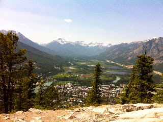
When we FINALLY made it to the top we had a nice break in the sun, had a little sunbathing session, and enjoyed the amazing view over Banff town and the surrounding mountains.

The walk down of Tunnel Mountain was easy and I enjoyed it compared to the hike up that day. And I on the way down promised my self that before I leave Banff in November I will be able to run up that little mountain, that took my the breath away from on my first hike. (I can tell you already now a month later I can easily hike it without needing any breaks – and in a pretty good pace, so I hope that I will be able to run it before I leave!)
But I’m looking forward to hike Tunnel Mt. with some of the coming seasoners for the winter season 2012-2013, and know that I will not be judgmental, because I can still remember my first time. 

Sulphur Mt.

The first time I hiked Sulphur Mt. was in March 2011, there was still a foot of snow on the trail, but my best friend was here visiting from Denmark, and I wanted to show her as much of Banff as possible, so of course she had to see Banff from above.
I remembered Sulphur Mt. being so hard, that I would probably never do it again. But the two of my roommates were hiking it 3 days later than I had hiked up Tunnel Mt. and I could not resist walking with them, when they agreed to wait for me, if I felt like dying again.

Again it was a stupidly hot day, 27 degrees, so we brought lots of water, and got ready for the hike. We walked downtown to take the bus out to the start of the trail (only because we’re lazy, but I would recommend doing that), it is a long walk out to the trail and gondola.
The first 2 kilometres/30 minutes of Sulphur Mt. did not cause me a hard time at all. It was hot, yes, and we needed some breaks to just drink some water but we were not exhausted. After the 2.3 kilometres we came to a little detour trail, we could see people walking around out there and decided to try it out, we were in good spirit, and I had not been complaining a bit about the hike yet. Actually I was doing really well. When we got to the end we saw a little spring, where we filled up all our water bottles with icecold spring water, SWEET, and we put our heads under to cool down a bit from the heat that was surrounding us.


After the little break we were more than ready for the rest of our hike, we were close to be half way, if we should believe the trail sign in the bottom that says 5.4km to the top.
I remember the last half an hour out of the 1 and a half hour being the hardest. So we have done a 3rd part of the trail we concluded and started hiking again. Easypeasy hike the follow half an hour, but when we hit that 4km point, where the trail has a steeper point we all started to get tired, and I was for the first time in the need of a break to catch my breath. It was good to know that there was only 1.4km left, and we could continue in high spirit.
I started a trail tracker/GPS when we started the hike at the gondola/bottom of Sulphur Mt. and I am still not sure, if my GPS is fucked or the trail sign at the bottom is telling the wrong distance, because the sign said 5.4km my GPS said 7.03km to the top. No matter what, we got a bit frustrated when my GPS passed the 6km mark, and we were still not at the top. But no way that we were turning around now, we could at least see the top, and it only took us another 15minutes to get up the last 1km. So my second time on Sulphur Mt was a good hike and definitely easier than the first and than I remember it.
When we got up there we walked around to the different viewpoints and just enjoyed the view and sun, just chilled out. We spent a bit less than 1 and a half hour on this 7km or 5.4km hike, and I’m gladly doing it again, know that I’ve erased the first horrible time I hiked Sulphur from my memory.

After we had enjoyed the sun for half an hour and got a bit to eat in the cafeteria at the top of Sulphur Mt. we decided to walk down on the opposite site of Sulphur Mt. to try something new. (Again the sign isn’t really that correct if I should believe what my GPS says. Sign: 8-something, GPS 10km to down town Banff, 11km to Cedar House.)
It is a REALLY beautiful way to walk down, there’s no trees around the trail like on the opposite site, where most people hike Sulphur from, so the view is just amazing. It is harder to walk down then you would think though. After our little spontaneous “let’s hike Sulphur Mt.” and then ended up with hiking Sulphur Mt. and walking down the other site, in total 7km of hiking up, 11km of walking down, plus how much we walked around on the top…… I was DEAD! I went straight to bed at 9pm., fell asleep and the day after I was so sore. But I will definitely do it again, if anyone is up for it!